
October 2017
This circular walk, based (loosely) on one from the AA’s 1001 Family Walks guidebook, is a lengthy route along the Coast at Clovelly, taking in the scenic fishing village with its idyllic cobbled street and colorful cottages that stretch up the steep incline from the fishing harbor. There is a lot of climbing here, so be prepared for a good workout.
If you have more time than I did, then you have plenty of locations to take in a nice cup of tea or even a pint of beer or a glass of wine at one of the numerous pubs, bars or tea rooms. If not, then don’t worry, because there is still plenty to see as it’s a strenuous little coastal walk that passes over clifftops and through woodland. You will also find a lot of pheasants along the way.

In the book the walk is just over 5 miles in length, by the time I finished I had done 7 and a half. I will try to inform you where I had gone wrong so you can make the choice. Once again you can follow the walk with the video from our channel.
Anyway, let the walk commence.
The walk starts in the National Trust Carpark at Brownsham, situated in between Hartland and Clovelly. Its a little difficult to find, but there are National Trust signs as you get closer. Use the postcode EX39 6AN and you should get somewhere in the vicinity… believe me, that’s more help than I had but I managed to find it. In the carpark, there is a little box for parking donations.
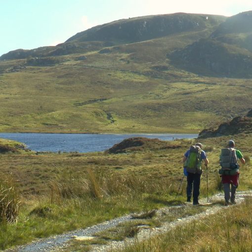
You leave the car park through the gate at the back and head down a path towards Buckland Woods, a beautiful and tranquil woodland. You simply follow the signs that read ‘footpath to coast path’ from here, until eventually you break out of the woods and into some fields, which you continue through until you join the coast path (Please note – when you do reach the coast path, carry on along the clifftops following sign to Mouthmill and through the fields, do not go down as I had, as this is going back on yourself, and which is where I added the first extra mileage to this walk.)

You stick to the path across the bottom of the field until the path begins to drop down towards a stile on the edge of another woodland. In here you zig-zag down until you break out once again at Mouthmill, where you come across some abandoned buildings on the edge of the beach. I took a walk out to the beach here and a look at the giant rock arch, but there is a bridge just before the buildings which takes you back onto the coast path.
Follow the path up through some more woodland, until you reach coast path signs, which you follow to the left (almost back on yourself) and immediately right. Prepare yourself for another big climb up this little wooded path until you break out once again onto the clifftop (Gallantry Bower) where you will be 400feet above the sea.
Follow the path through the gorse until you enter some more woods, through a kissing gate, and the AA book tells you to follow signs for “Angels Wings Folly”. Now I didn’t see this sign but managed to take the correct route as I met a cross junction and took the left-hand turn. Before long I stumbled upon the Angel’s Wings’ Folly, a nice little shelter with beautiful carvings in the woodwork of …. wait for it… angels and angel wings. You can pause for a while here if you so wish before continuing on past.

Keeping left where the path leads straight to the church, you will come out of the woods through a metal kissing gate, and into the open land of Clovelly court estate. Shortly you will meet another kissing gate into laurel woods and keep on the path which leads you past a stone shelter, and through another kissing gate and into a field… or so the guidebook said.
This is where I took a different route I am sure, as the gate I found (bearing in mind that I had kept left here) was a tired old gate that would neither open and barely looked man enough to take my weight. I did climb it however (always climb gates on hinge sides if you do have to as less likely to cause damage) and came out onto the road.
(In hind site I think that the book suggests that you veer right here, and will come out on the road near the visitor centre. This does cut out the most scenic part of the walk though, the fishing village, which is beautiful but will have a very big climb. If you do choose to miss this, then skip on now until I reach the visitor centre myself.)

So, I am out on the road and chose to take the left again, continuing down the hill, and entering the village from the back. Keeping left walk around he back of the buildings and you will eventually come out at the harbor where the views of the quaint village are well worth a look, and from here it looks like a model village.
The Red Lion Hotel that sits on the harbor would be a great place to get yourself a pint if you like, in preparation for the next climb of the day.
Walk past the hotel, and follow the cobbled path up and to the left, and simply follow it up and you will soon pass through the steep cobbled streets, littered with sleds that the residents and fishermen use to ferry their goods. Ther are a couple of shops and tea rooms etc up here too. In summer I am sure you have to pay to go down this street from the top, I am not so sure you will have to from this route, though, as I didnt.

Once up the top, and leaving the village behind, you reach the main road on the corner where the visitor centre sits. You are back on track with the AA book now. Across the road, and to the left of the visitor centre you will see a narrow cobbled path called Wrinkleberry Lane. Follow this for another uphill climb, and you will pass the Route 39 Academy, first a small school building on your left and further up the road a larger building on your right. Keep walking until you reach a T junction, where you will take a right, down the hill.
At a sweeping right-hand bend you will see the entrance to the Clovelly Court estate. Enter here and follow the bridleway signs towards ‘Court Farm and Sawmills.’ The book simply says ‘through farm. At end of buildings keep ahead on track between fields. Pass through plantation and bear Right downhill across field as signed. I did pass through a small field, cattle- gridded at either end and with a tarmac road through it. A word of warning, when I passed through here there were horned cattle in it, so be cautious, don’t panic and be sure not to run if they get inquisitive.

You will reach a gate with a bridleway sign on it – go through this and you will enter another field, this one has woodland along the bottom of it to your right. Veer towards the trees and you will see a large gate in the corner of the field which enters the woods, and if you look, following the line of trees to the left, you will see another smaller gate which seems to run alongside where the trees jut out – this is where I headed, and it seemed to be right.
The book here confused me a little more, telling me to follow bridleway signs through the forest, but I met a junction where there were bridleway signs pointing in numerous directions. So looking at viewranger after wards I can see that I went right at the first junction then left at the next. Then it was a steady up hill climb through the forest, until I reached the back edge of Brownsham, by th etea room. Follow the road around to the left and you will finally reach the National Trust carpark where we began.

Leave a Reply