

This walk took place on the 6th January 2018, before I had decided to embark on my personal mission to walk the entire South West Coast Path. Its a 6 mile circular walk around Boscastle, that for the final third brings us back along the clifftops of the Atlantic ocean. There is a lot of ascending and descending involved in this walk, and can be quite strenuous in places. You can watch my video of it here!
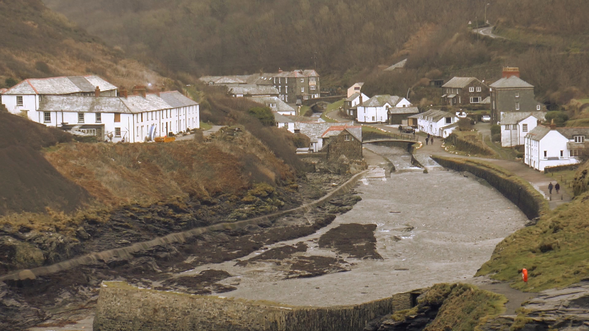
Boscastle is a quaint little village and fishing port in North Cornwall. It was the site of the historic floods in August 16th 2004 which saw 440 million gallons of water flooding through the village, from the steep hillsides and through the three rivers that channel into the village. Amazingly no lives were lost, but the damage caused would amount to millions, demolishing the village bridge, four buildings and sweeping one hundred and fifteen cars into the harbour. So, its probably best that you choose a relatively dry day to take this walk on.

The walk begins in the main car park at Boscastle, and to find the trail you have to walk out of the back of the car park and alongside the river up what is known as the Valency valley.
Walk for a short distance passing through a woodland (beware in wet seasons this can be very muddy so be sure to wear adequate footware) until you reach a footbridge that crosses the river, signposted to Minster Church. Don’t cross it, but pass it heading towards St Juliot Church. Keep on this path until the path forks, and you head left, up hill towards New Mills.
There is a bit of a climb now to get away from the valley. At New Mills, you reach a lane which zig zags up the hill. Follow the zig zags heading away from Elm Cottage. As you gain some height the views of the rolling hillsides and valleys opens up. Follow the road as it curves to the right, passing the farm, until you reach the main road. Then turn right, and after a short distance turn left onto a narrow lane.
Stay on this lane until the bottom of the valley and take the sty on the right. Walk in through the field, heading towards the gorse bushes at the top. You will see a gap in the bushes, head through this and then through the gate into the next field, then aiming to the right hand side of the house until you come out once again onto a lane. Turn right, walk past manor farm and turn left at the junction. Past North Lodge, you will see a sign to the coast path up a little path, follow this, but be careful where you step along this lane as it was full of dog mess when I passed through it!

At the end of the lane walk through another gate and enter another field. Walk beside the hedge until you join the South West Coast Path. This is where the walk becomes a bit more interesting, as you reach rugged coast line and towering clifftops. Follow the coast path left, and keep your eyes on the coast as along here I was fortunate enough to spot a seal.
Head to Fire Beacon Point, and then onto Beenie Cliff, which is a great vantage point of the cliffs ahead, with views of Tintagel off in the distance, and one of the coast paths many memorial benches is situated here, so a good spot to rest for a spot of lunch. Then, continue along the path, decending down the steep path, which can be quite slippery under foot. At the bottom of this decent was the precise place that I saw the aforementioned seal, just off of the appropriately named Seal Hole.
The coast path carves its way along the cliff face, and over numerous valleys, so be prepared for a lot of climbing and descending from here on in. After climbing down from Beanie Cliff the path winds down and up then down once again towards the Pentargon waterfall at Hillsborough, a waterfall of 120 feet. From here you can see the Quartz stones at the foot of the opposite cliff faces. Cross the footbridge at Pentargon and then ascend once more, this time up steps carved, and onto to the clifftops which you will now walk along until you reach the mast of Penally Hill.

On the top of Penally Hill the village and harbour of Boscastle comes into view, like a little model village. From here, you descend down the cliffs towards Penally Point. Beneath this cliff path is a blow hole carved from one side of the cliffs to the other, which when the tide is in you can hear thundering and booming as the waves crash into it. The path turns to rocks as you walk over to Penally Point, so once again take care, in wet conditions the rocks are slippery.
Once out on the rocky outcrop of Penally Point, you can get some fantastic views of the harbour behind you, the cliffs ahead and behind you. This is the end of the walk, so about turn, and make your way back down towards the village, passing the harbour and walking back alongside the river until you get back to your start point. In my walk, I crossed the bridge to get a look at the blow hoel from the other side of the harbour before heading back.

As you head back marvel at the interesting layout of the village, with the turret shaped Wellington Hotel and houses up on the hillsides. If you still have time, take in the fascinating Museum of Witchcraft beside the river, stop for a tea in the National Trust tea room, or even get some new walking clothes or gear in the Cornish Rambler.
Leave a Reply