JUNE 2016
An account of our first bad weather hike on Dartmoor

This 8 1/2mile (13.6km) walk takes us into the Okehampton Range area – so it is worth checking that there are no military exercises taking place on the days you may wish to follow our route.
It takes in 6 squares of the DARTMOOR 365 map (get your copy here) – C9, C10, C11 D11, D10, D9
Our first three walks into the vast landscape of Dartmoor National Park had been lucky, or so I had been told by numerous people. For each of those walks had seen us blessed by the presence of sunshine, blue cloudy skies, and the seemingly endless views that surrounded and spanned away from the Tors. That, I was informed, wasn’t the real Dartmoor experience.
It was on our fourth outing, deep into July 2016, the supposed summer, that we were first to meet the real Dartmoor.
Please note, that there are much easier routes than this to hop from each of these tors, but this was early Summit or Nothing, and we really didn’t have much of a clue what we were doing back then. Also, this is really a blog but I have numbered the areas where navigation is involved should you wish to follow our footsteps.

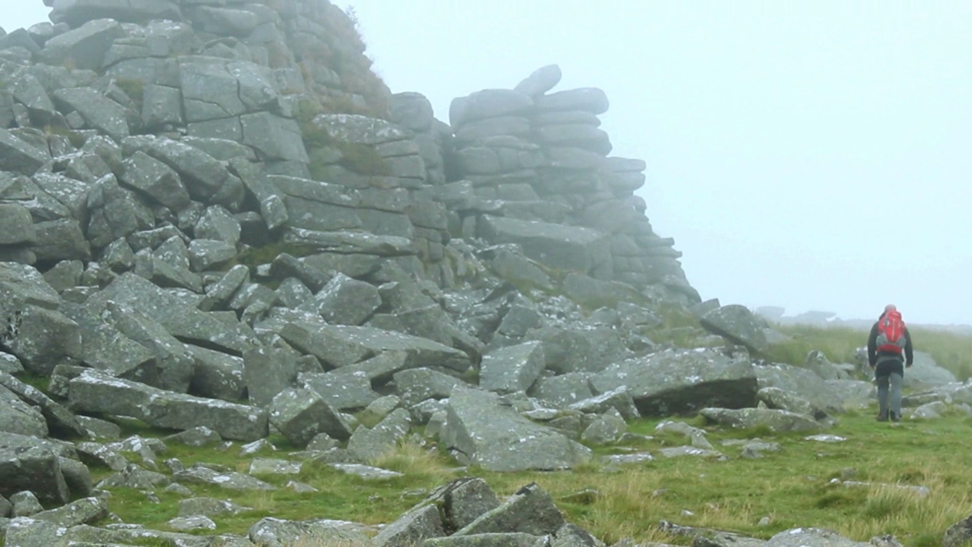
Apparently, the views from up on Cosdon Hill are amazing, and you can even see Haytor which resides a huge distance away, in South Devon. The day we chose to explore this area, the mist was thick, and the moisture it brought with it was harsh and soaking. This was going to be a real test of our (Nath’s) map reading skills.
We started this 8 1/2 mile (13.6K) walk off on the wrong foot anyway when we first pulled up at our starting location and got our maps and compasses out to establish exactly where we were, only to realise that both of our compasses were pointing in different directions, and neither to a true North! We soon established that it was due to us being sat in a car… we think. Anyway, this is the route we took, the things we saw and the miles we did on this damp ad foggy day.
1. Coming into the moors through Okehampton and heading past Okehampton Camp, we basically chatted happily before we realised that we had not paid attention to where we had gone and had no idea where we had ended up, but after a little while of studying our map and our surroundings we soon established that we were parked just beside the kink in the range markers at East Okement Farm with East Mill and Oke Tor’s looming over us to our South.
2. However, we headed East, following the farm fence until we joined a stony road which leads down into the valley where the Okement River is passable with a small amount of hopping from one side to the other. Once across, we continued to follow the road uphill heading North, until we reached Winter Tor on our right-hand side, which we examined for a brief spell, before heading north-east into the moor and up towards the mountainous granite stacks of Higher Tor.

It was once we were up on the heights of Higher Tor that the weather began to really sweep in, and our visibility went from poor to abysmal.
After strolling up and beyond Irishman’s wall (an impressive wall that we can only assume was built by an Irishman or a collective of Irishmen) to Belstone Tor, we soon decided that settling back in the shelter of Higher Tor and having a brew may be the best choice for now, and we waited for a break in the mist so we were able to take a better bearing.
3. It wasn’t long before the veil of pea-soup mist had risen, and as soon we could see exactly where we wanted to head (a loop in the River Taw at the bottom of the next valley which we had identified on the map), and which we could now see in the respite from the treacherous weather, in real life with our actual eyes. So we headed East off of Higher Tor, and clambered down an abysmal stony hillside, thanking our lucky stars that we made it to the bottom without shattering our ankles.
4. The climb up to the top of Cosdon Hill was a long and thankless walk. We could barely see twenty meters in front of ourselves as we made our way up this featureless hill, not knowing if we were on the right track, or walking past the top of the hill.
We were trying to find Cosdon Beacon, and if it wasn’t for Nathan’s orienteering skills, we may have just walked past it. By reading the gradience of the hill under our feet, Nathan determined that we had veered to the right and reached a plateau that was evident on the map – from where he made an educated guess of the direction we should be heading in, and low and behold, we reached Cosdon Beacon.

It was here, that our first ever full blast roar of SUMMIT OR NOTHING took place, and after the ordeal of what seemed like an endless walk to reach the summit – it was both a great release and a roar of achievement. It would soon become a staple of our channel, noisy bastards that we are.
We chose to stop here for our lunch, and of course, the mist lifted as we sat and ate, enough to expose some impressive tors off in the distance, on the opposite side of the Hill than we had arrived. I wondered what those Tors were, and when I worked it out with my map and compass was surprised to realise that they were Higher Tor and Belstone Tor, precisely where we had traveled from, which just goes to show how easy it is to lose your bearings on Dartmoor, especially in the mist.
5. Soon we were ready to leave the summit of Cosdon Hill and headed for 2KM South along a well-trodden path towards the stone circle of Little Hound Tor, known as White Moor Circle. Of course, once on the move again, the weather became even worse than it had been in the morning. Horrendous in fact, so much so that we decided to rubber up, and donned our waterproofs for the remains of the day.
So there we were, walking along the bleak moor, in zero visibility, with waterproofs on, a map and compass around each of our necks, when we met a man wandering along with his dog, dressed in jeans and a T-shirt, soaked to the bone, with no map, no compass asking us casually ‘Do you know how to get to Sticklepath from here?’ as though he had just pulled us over in a street.

Nath was absolutely stunned. He pointed the chap North, towards Cosdon Beacon, but couldn’t hide his contempt for such a dim-witted fool, wandering the dangerous moors in dangerous conditions, dressed for the beach. It actually made us feel a little more responsible than we usually did. We, who were often frowned upon in the hiking circles for not being precious about the majesty of rambling, and yet here we were, proud to have a bit of one-upmanship over someone else far more unprepared and uneducated than we.
Anyway, we soon reached the stone circle, the first that I had seen on Dartmoor, an impressive little circle that we have since learned is situated in a location with fantastic panoramic views. We will have to take their word for that! We were also informed that there is a particularly treacherous mire to the north-east of the circle, which I am surprised to say, we didn’t stumble across. Who’d have thought it?
6. From the stone circle, a little walk SW for about an eighth of a kilometre, and we reached the summit of Hound Tor, which marked the beginning of the end of our walk. From here we were heading back towards the car, in a roundabout sort of way.
7. We went West, back down into the valley and across the River Taw once again, before taking the laborious climb up to the top of Steeperton Tor, a miserable little hut, and mast in the middle of this bleak and grey landscape.

I was not impressed, but after the climb I was glad to take ten minutes here to compose myself. And for reasons I still can’t comprehend, Nath later confessed (and I mean many, many months later) that this particular rest spot happened to be his favourite moment of Summit or Nothing so far, something about the bleakness, the weather, the day we had endured – as I said, reasons that I cannot comprehend.
8. From here, we could have bee-lined from Steeperton to Oke Tor, and knocked that one off of our list, but for more reasons that I can’t comprehend, Nath had us heading backward, away from our car, until we found a track that lead us to our car was the better option. In hindsight from the number of times we have wound up stuck in the bog, he probably was right, and besides, I had a dodgy ankle that day. It was a long walk anyway, back to the car, probably 3 or 4km along the road, and of course, as we approached the car, the rain eased off and the mist began to lift. Of course, it did!

Leave a Reply